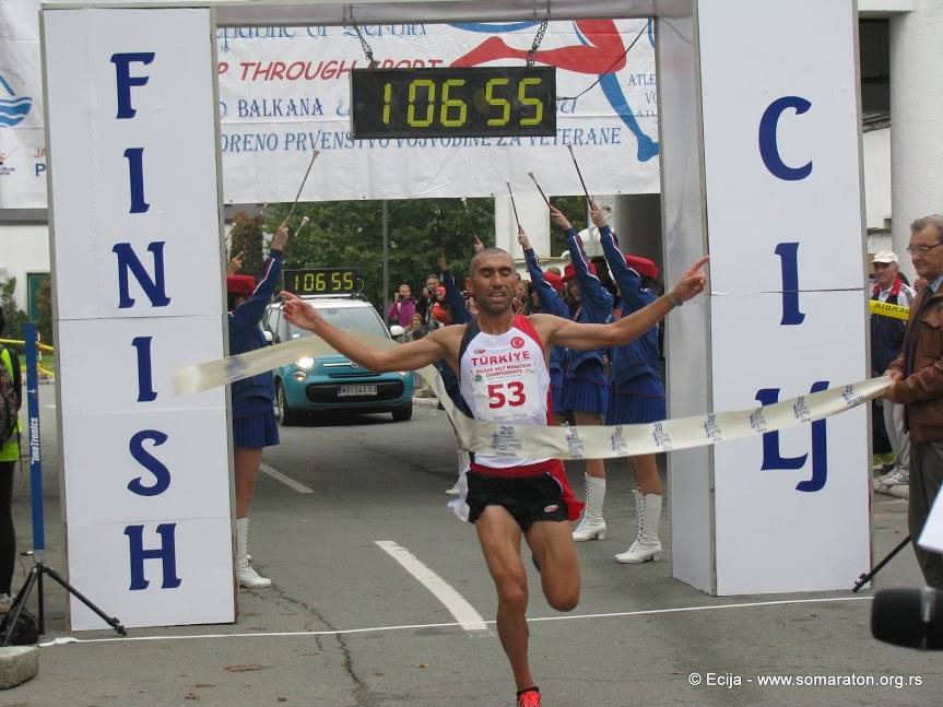
HOME APPLICATIONS NEWS PARTNERS CONTACT
SRIzbor jezika HUIzbor jezika ENIzbor jezika
About Apatin
Apatin
Among the first inhabitants of today's Apatin from ancient history, the cultures of the Sarmatians, Celts and Goths are mentioned. Apatin was ruled by Slavs, Germans, Hungarians and Turks, under whose rule the city was for 140 years. The city center with a church and a square was originally located near the Danube right next to the former pier, but during the catastrophic floods in the 18th century it "disappeared" as well as half of the settlement, so a new center was formed northeast of Apatin Brewery. measures preserved to this day. Speaking of Pivara, the most famous brand of our city, we believe that you are all well aware of the year 1756, which you have read so many times on the Jelen piva label. It was in that year that the Apatin Brewery was founded, which is known today outside the borders of Serbia.
The municipality of Apatin is located, within the area of Vojvodina, in the far west, that is, in the area of western Backa. Extremely favorable geographical position, positioning directly along the left bank of the great international river Danube / so-called. "blue European highway" /, represents a great potential of the municipality. In addition to this natural, western border, the municipality of Apatin borders the territory of the municipality of Sombor in the north and northeast, and the municipality of Odzaci in the south and southeast. In addition to the city of Apatin, which is an administrative, economic, educational and cultural center, in the municipality of Apatin there are 4 more settlements of rural character: Svilojevo, Kupusina, Prigrevica and Sonta.
The municipality of Apatin belongs to the zone characterized by a temperate continental climate with four seasons. The average air temperature ranges from a minimum of -1.80oC (during the month of January) to a maximum of 21.20oC, during the month of July (with an annual average of 10.80oC). The lowest registered temperature was -25.60oC, while the maximum temperature reached 40.20oC.
A BRIEF HISTORY OF APATINA
Extremely favorable geographical position, proximity to the river and natural resources of this area (fertile land, forests along the river, abundance of fish on the marshes and backwaters and game in the forests) have always attracted people to settle here, so even in prehistoric times Sarmatian cultures change, Celts, Goths and other peoples.
In the first century, during the Roman conquests, the settlement was turned into a military trench with fortifications and played a significant role in the defense of the province of Pannonia. In the 6th century, the Slavs came, and in 896, the Hungarians founded their state in this area, in which the Slavs still made up the majority of the population.
Apatin was first mentioned in written documents in 1011, and was named after the abbey of the Kalocka diocese. In the 14th and 15th centuries, there were feudal estates in this area, whose lords built castles around which fishermen, hunters, boatmen and millers settled. In 1417, Apatin is mentioned as the property of Stefan Lazarević. It fell under Turkish rule in 1541 and was under it for a full 140 years.
Some of the refugees from the great migration under Arsenij Čarnojević settled in Apatin, Sombor and Prigrevica in 1690. In 1748, German colonists came to Apatin, and Serbian settlements were forcibly displaced, mostly to Stapar. The colonists came from all over. The collection center was in Ulm, and from there they were transported by the Danube to Apatin, which became the main base of German expansion in Vojvodina, receiving special support in development. Not far from the port, a church was built and a center with a square was built. Public buildings, schools, fishing stations, craft workshops and residential buildings are being erected. The court chamber rapidly erected commercial facilities: in 1756 a brewery and a baker, and in 1764 one of the largest textile workshops in Bačka. In 1760, Apatin was declared a city and a permanent trading post with a special status.
At the end of the 18th century, a catastrophic flood penetrated the old center, destroyed it with all its buildings, and took half of the settlement with it. The new center was formed northeast of the Brewery, which established the shape of the city, which has been largely preserved to this day. During the 18th and the first half of the 19th century, Apatin experienced a strong economic rise, primarily thanks to crafts, trade and shipbuilding. As early as 1869, banks and savings banks were established, which opened the door to accelerated industrial development. A large number of brickyards (36) produced bricks and tiles, and many buildings in Vienna and most in Pest were built and covered with them. In 1912, Apatin was connected by railway with Sombor and Sonta. In 1920, a shipyard was founded, which has recently been modernized and is the only one along the entire Danube equipped with a special elevator for quick hauling of ships to the dock.
After the capitulation of Yugoslavia in 1941, Apatin became part of Horthy's Hungary. During the Battle of Batin, the front stretched all the way to Apatin and Bogojevo, and the city itself became a real war base. Partisan units liberated Apatin on October 24, 1944. years.
According to the plan of colonization, in November 1945, the first veteran families from Lika arrived in Apatin and the national composition of the city was changed. By 1953, a total of 1,061 families with 6,258 members were settled.
(Texts taken from: 025info.rs and soapatin.rs)